
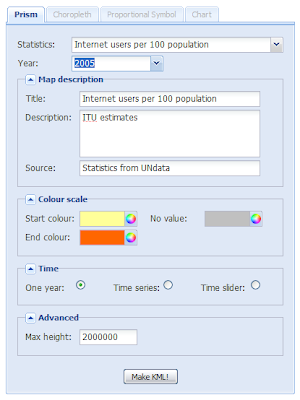
It's time to introduce the Thematic Mapping Engine (TME). In my previous blog posts, I've shown various techniques of how geobrowsers can be used for thematic mapping. The goal has been to explore the possibilites and to make these techniques available to a wider audience. The Tematic Mapping Engine provides an easy-to-use web interface where you can create visually appealing maps on-the-fly.
 So far only prism maps are supported, but other thematic mapping techniques will be added in the upcoming weeks. The engine returns a KMZ file that you can open in Google Earth or download to your computer. My primary data source is UNdata.
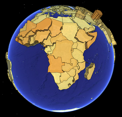 The above visualisation is generated by TME (download KMZ) and shows child mortaility in the world (UNdata).
The Thematic Mapping Engine is also an example of what you can achieve with open source tools and datasets in the public domain:
Try Thematic Mapping Engine
Please give your feedback by posting a comment below!
So far only prism maps are supported, but other thematic mapping techniques will be added in the upcoming weeks. The engine returns a KMZ file that you can open in Google Earth or download to your computer. My primary data source is UNdata.The above visualisation is generated by TME (download KMZ) and shows child mortaility in the world (UNdata).The Thematic Mapping Engine is also an example of what you can achieve with open source tools and datasets in the public domain:
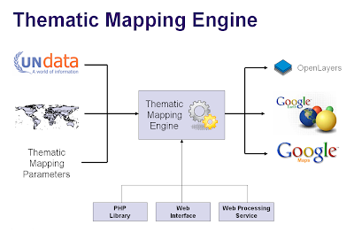
- A world border dataset is loaded into a MySQL database. The same database contains tables with statistics from UNdata.
- A PHP script generates KML by querying the database and adding styles according to the parameters given by the user.
- Map legends are generated on-the-fly using the GD graphics library.
- All files are zipped into one KMZ file which are stored on a web server. A link to the file is returned to the user.
- The user interface is build with Ext JS and AJAX techniques.
Try Thematic Mapping Engine
Please give your feedback by posting a comment below!
Comments
I cannot see where I can download the TME?
TME is not yet available for download.
It seems to work here. Could you plese send me one of the KMZ files with errors?
bjorn@thematicmapping.org
Nice app, BTW! Are you going to add the ability to import your own data?
I used some of the UNData to create a kmz that shows the prevalence of HIV/AIDS at country level (see here)
An idea: you can integrate the new Google Earth API on the web, and see the KMZ on the fly on your web explorer (without GoogleEarth desktop application).
Yes you can. See my comment on this page.
Any chance you can add "Cellular mobile telephone subscribers (ITU/SYB50)" and "Cellular mobile telephone subscribers per 100 inhabitants (ITU estimates)" from UNdata to your list of data sources?
Nice!
FYI, I have a tool to make choropleth maps from user-provided data at
http://maps.webfoot.com/mapeteria
It is not as slick-looking as yours, though. :-)
(And Simon, you can make a KML file of the ITU data with Mapeteria if you don't want to waite for the polish of TME...)
I like the technique, thematic maps are powerful tools and good to see you making it easier to produce them in GE. However, IMHO prism maps don't really work in GE, simple color differences works much better. For more detail see here
.
Rich
Simon:
I'll add "Cellular mobile telephone subscribers" in the next version of TME ("released" one day this week)
Kaitlin:
Mapteria looks nice (I'll try it later). I especially like the possibility to visualise statistics on per capita or per area basis.
Rich:
I think prism maps works very well in Google Earth. I'll write a blog post about "why 3d works" shortly.
I am an intern for the Institute for Creative Technology working on a project for Cultural Environmental Annotations. I stumbled onto this "Thematic Mapping Engine" and found it to be very intriguing. My concentration is in the area of ethnocultural characteristics with focus on dominant ethic cultures world wide. I am interested in learning more about embedding UNdata of ethical dominance into TME that would allow me to use this source as a plug-in to GE. Is this possible, and how do I do it?
Your project sounds interesting. What are the geographical units of the "ethnical dominance" data?
If you have data on country level - I'm happy to include samples in my database, as long as the data can be used without restrictions (non-profit use).
Thanks
You could try GMapCreator from CASA.
cool tool. However when using danish æ,ø and å in description fields it's look strange. Do you plan to support all the unicode characters for your tool?
Of course we need æ, ø and å. I thought the engine already supported unicode, - I'll have a closer look.
Congratulations !!
I'm a brazilian oceanographer and developed a application to spacialize sustainable development indicators using GD Library of PHP. It's so easy and useful !
I'll register my email at this site and wait anxixously the notice of the download opportunity !
I think that FOSS is a good solution to the problems of everybody ! So, I wish that You'll obtain sucess with this great initiative !!
Best regards,
Raquel Dezidério Souto.
Great work !
I'd like to use your tool and try to integrate in my own mapfish application. Would you share the source ? (guru_wireless@yahoo.fr)
Hi i have a client jps application.
It produce tabular data.
Is it possible use your engine as server to produce thematic maps?
I wish to have a mush-up solution for Spatial OLAP.
Thanks
Sandro
(you can contact me at saxbim@libero.it)
I am amazed with the wonderful tool you have developed.
I am not familiar with PostGIS, MySQL and Php programming, but only VB, Access and Excel. I have some country statistics in MS-Excel and MS-Access that I would like to see ploted in a kml format. So I have 1 questions and 2 suggestion.
Question: Do you have the code in VB to read from shapefile and another code to create a KML file? Since I think you may not have it at hand, I have a suggestion.
Suggestions: The engine you developed is great, so why don't you develop a format in DBF or TXT/CSV, so that any user could upload a file (with country name/index and the statistics) to the engine, make all the setup and receive a nice KML file? It would be also lovely to have a stand-alone version of the engine to run it in a Windows environment.
Thank you in advance and congratulations for your nice blog.
(geoffrey, geography teacher)
Thak you so much for the amazing Blog. I learned lots of things on thematic maps thanks to you.
Any chance you release the source code of TME in the future ?
Very very very good job.
Can't wait for the ability to import our own data!
When I type a big number in the number of classes, it says 'engine failed'. (Actually, sometimes even you input 10, it says engine failed)..
Maybe you forgot some error check on the relationship between numOfDistinctValues and numOfDefinedClasses. If(numOfDistinctValues '<'numOfDefinedClasses), the situation is the same as unclassified.
You might want to take a look at this:)
But, I am still stuned by what you did!
where i can download the TME??
http://data.un.org/Data.aspx?q=cancer&d=WHO&f=inID%3aMBD23
Cheers
Sebastian
You need to download the source to add your own data to TME. I'm working on a more flexible solution.
Bjørn
a.fetchKmlUsingHelper_(b,f)
testing yet.
do you know what can it do ?
thanks for advance
congratulations about your tools
Cheers,
Emariana Widner
Kent State University
Ohio, U.S.A
Please let me know soon. Thanks.
Dr. Jack Kinworthy-Lincoln, Nebraska USA